---
title: Configuration of Base Map Layer
description: Learn how to set up your base map layer and explore the different map view options Proqio offers.
---
[Skip to content](https://help.proqio.com/configuration-of-base-map-layer#main-content)
[](https://help.proqio.com/?hsLang=en)
Open main navigation
Close main navigation
How can we help you?
- There are no suggestions because the search field is empty.
1. [Knowledge base](https://help.proqio.com/?hsLang=en)
2. [Configure Your Map View](https://help.proqio.com/configure-your-map-view?hsLang=en)
# Configuration of Base Map Layer
## In Proqio the base map layer provides the geographic context and visual foundation for a project. It typically includes terrain, roads, landmarks, or imagery and sits beneath operational layers. Configuring the map layer in Proqio ensures the project is both informative and visually coherent.
### Map View Options Available on Proqio
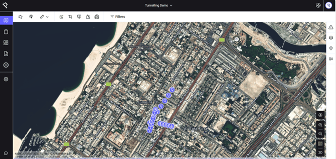
#### **Satellite**
- Uses real-world imagery captured from satellites. Shows natural landscapes, buildings, vegetation, and terrain as they appear from above.
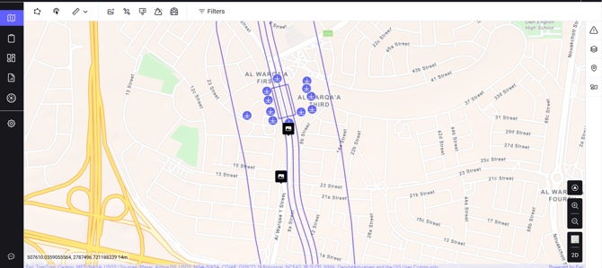
#### **Street**
- A simplified, traditional map layout with roads, labels, and place markers. Useful for navigation, urban planning, or infrastructure mapping.
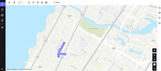
#### **Relief**
- Adds shading and contour lines to indicate elevation and landscape features.
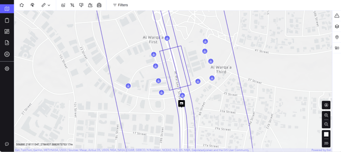
#### **Monochrome**
- A grayscale version of the standard map. Perfect when you want project layers to stand out or when printing.
#### **3D Buildings**
- Displays structures in a three-dimensional view within urban areas. Excellent for architectural design, city planning, or immersive mapping.
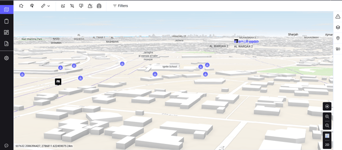
When selecting the 3D building the software changes automatically to the 3D view.
---
### **How to Select Different Map Options**
1. Go to **Maps**, first option from the top left side of the page.
2. Find **Map Style**, second option from bottom on the right side on the Map.
3. Choose from the Map style (Satellite, Street, Relief, Monochrome, and 3D Buildings)
4. Find Map View, Last option on the right side of the page to set the dimension (Like, **2D/3D**)
Please note:
- By default, the map is shown in 2D.
- The button below the map on map indicates the *alternative* view (refers to 2D/3D view option) and not the current one.
- For example, if you’re in the 3D view, the button will display “2D,” meaning that clicking it will switch the map back to 2D.
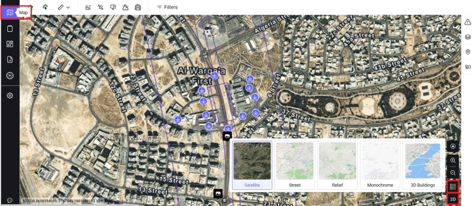
Also please note that changes made on this page are temporary and will revert to default map settings once moved to a different map view.
---
### **How to Configure Your Default Map Style**
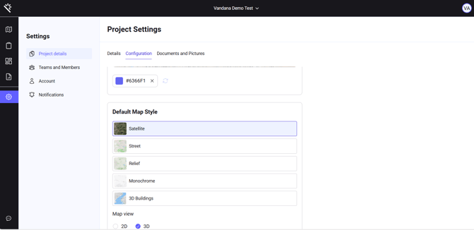
- Go to **settings**, the gear icon last option from top left side of the page.
- Under settings select **Project Details**, then go to Configuration, which is the second option on the right panel.
- As shown in the image below, you can select **Default Map style** (Satellite, Street, Relief, Monochrome, and 3D Buildings) and Dimension (2D/3D).
- By configuring Default Map Style, we can permanently set the Map style as per requirement that can be modify through settings.
Please remember 3D building can only be displayed on the 3D view
****
- [Getting started](https://help.proqio.com/getting-started?hsLang=en#main-content)
- [Project details](https://help.proqio.com/getting-started?hsLang=en#project-details)
- [Teams and members](https://help.proqio.com/getting-started?hsLang=en#teams-and-members)
- [Account](https://help.proqio.com/getting-started?hsLang=en#account)
- [Configure Your Instruments](https://help.proqio.com/getting-started?hsLang=en#configure-your-instruments)
- [Notifications](https://help.proqio.com/getting-started?hsLang=en#notifications)
- [Connectivity methods](https://help.proqio.com/getting-started?hsLang=en#connectivity-methods)
- [Alerts](https://help.proqio.com/getting-started?hsLang=en#alerts)
- [Map](https://help.proqio.com/map?hsLang=en#main-content)
- [Tools](https://help.proqio.com/map?hsLang=en#tools)
- [Analysis](https://help.proqio.com/map?hsLang=en#analysis)
- [Monitoring](https://help.proqio.com/monitoring?hsLang=en#main-content)
- [Instruments](https://help.proqio.com/monitoring?hsLang=en#instruments)
- [Dashboard Creation & Configuration](https://help.proqio.com/dashboard-creation-configuration?hsLang=en)
- [Report Creation](https://help.proqio.com/report-creation?hsLang=en)
- [New Feature Releases](https://help.proqio.com/new-feature-releases?hsLang=en)
- [Project Hierarchy](https://help.proqio.com/project-hierarchy?hsLang=en)
- [Analyse and Interpret your Data](https://help.proqio.com/analyse-and-interpret-your-data?hsLang=en)
- [Learn How to Navigate Proqio](https://help.proqio.com/learn-how-to-navigate-proqio?hsLang=en)
- [Configure Your Map View](https://help.proqio.com/configure-your-map-view?hsLang=en)
- [How to Add a Real Time Picture on Map](https://help.proqio.com/how-to-add-a-real-time-picture-on-map?hsLang=en)
- [Managing Your Data](https://help.proqio.com/managing-your-data?hsLang=en)
- [Uploading Records Manually](https://help.proqio.com/uploading-records-manually?hsLang=en#main-content)
- [Steps for uploading instrument data records manually](https://help.proqio.com/uploading-records-manually?hsLang=en#steps-for-uploading-instrument-data-records-manually)
- [ADA](https://help.proqio.com/ada?hsLang=en)
- [Digital Twin](https://help.proqio.com/digital-twin?hsLang=en)
- [Lines and Textures](https://help.proqio.com/lines-and-textures?hsLang=en)
[](http://www.proqio.com?hsLang=en)
Copyright © 2026, Proqio